Gernot Walzl

Drones

Unmanned Aircraft System (UAS)

Contents

Map

Here is a map to find safe flight locations for drones, model airplanes
and other unmanned aerial vehicles (UAVs) in Austria:

Model Flying Fields in Austria

GeoJSON

This map loads the data from the following GeoJSON files:

OeAeC_MOD_001-i16a_modellflugplaetze.geojson
Data source: OeAeC_MOD_001-i16a_modellflugplaetze.pdf
austrocontrol_zones.geojson
Data source: https://utm.dronespace.at/avm/
dji_geozones_at.geojson
Data source: https://fly-safe.dji.com/nfz/nfz-query

DJI FPV

SRT files

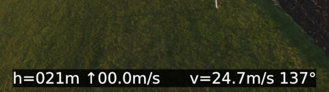
The DJI FPV drone records SRT files to track GPS coordinates and other
information during a flight.

dji_fpv_srt_telemetry.py

This Python script reads the recorded SRT file and calculates height,
vertical speed, horizontal speed and direction. The output is written as
a subtitle file (WebVTT, SRT) that can be used as an overlay for videos:

DJI FPV SRT Telemetry

dji_fpv_srt_geojson.py

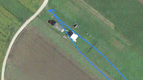
This Python script reads the SRT file and writes the recorded flight track
as GeoJSON LineString that can be used as an overlay for maps:
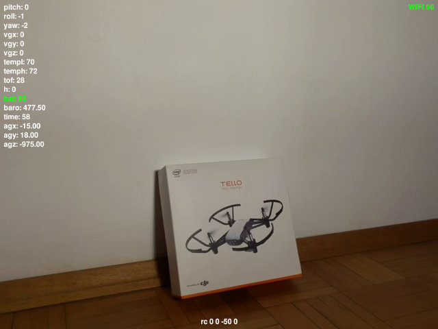
DJI FPV SRT GeoJSON

Tello

SDK

The Tello drone provides an API to control the drone, to receive the stream
from the camera, and to receive status information.

tello_rc.py

This Python script shows the video stream of the drone's camera on screen
and allows you to control the drone via keyboard and/or gamepad:

Tello RC
CONTENT.html source 2024-01-14 3.4 KB
OeAeC_MOD_001-i16a_modellflugplaetze.geojson source 2023-02-18 45.6 KB
austrocontrol_zones.geojson source 2024-01-14 546.4 KB
dji_fpv_menu.html source 2023-09-08 11.6 KB
dji_fpv_srt_geojson.jpg 2023-03-08 36.4 KB
dji_fpv_srt_geojson.py source 2023-02-18 3.3 KB
dji_fpv_srt_geojson.py
2023-02-18
by Gernot Walzl
The DJI FPV drone records SRT files to track GPS coordinates, altitudes, etc.
This script converts the recorded track to GeoJSON.
dji_fpv_srt_telemetry.jpg 2023-03-08 14.1 KB
dji_fpv_srt_telemetry.py source 2023-01-12 8 KB
dji_fpv_srt_telemetry.py
2023-01-12
by Gernot Walzl
The DJI FPV drone records SRT files to track GPS coordinates, altitudes, etc.
This script calculates speed, height, etc. of the drone and writes subtitles
dji_geozones_at.geojson source 2024-01-14 205.5 KB
dji_mini_subtitles.py source 2023-09-16 3.8 KB
dji_mini_subtitles.py
2023-09-14
by Gernot Walzl
The DJI Mavic Mini drone records subtitles to track GPS coordinates, altitudes, etc.
To extract flight data stored in subtitles, ffmpeg can be used:
model_flying_fields_austria.html source 2024-01-18 7.4 KB
tello_rc.jpg 2023-03-08 28.7 KB
tello_rc.py source 2023-03-08 13.2 KB
tello_rc.py
2022-04-30
by Gernot Walzl
This script interacts with the DJI Ryze Tello drone.
The drone can be controlled via keyboard and/or gamepad.